Tuesday, November 22, 2011

Global Science Final Exam

Question #4: Plate Tectonics Theory:


(http://www.google.com/imgres?um=1&hl=en&sa=N&biw=1366&bih=667&tbm=isch&tbnid=wFDTnhmcz87EnM:&imgrefurl=http://www.enchantedlearning.com/subjects/astronomy/planets/earth/Continents.shtml&docid=LysORMv67tYFQM&imgurl=http://www.enchantedlearning.com/egifs/Earthsplates.GIF&w=431&h=252&ei=Gp3KTsreBsKisQK8qtUq&zoom=1&iact=hc&vpx=1039&vpy=203&dur=875&hovh=110&hovw=188&tx=212&ty=100&sig=100894702643995253240&page=1&tbnh=103&tbnw=176&start=0&ndsp=18&ved=1t:429,r:5,s:0)
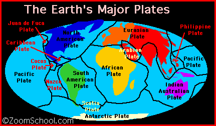
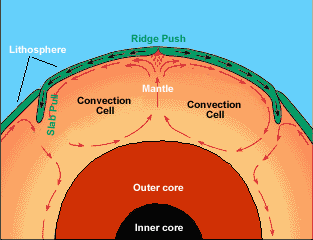
Plate tectonics are responsible for sea floor spreading. Sea floor spreading is when the tectonic plates of the ocean floor move apart, extending the sea floor. Through the crack that the spreading creates, magma seeps out like an undersea volcano. The magma cools and becomes solid when the water reaches it which extends the size of the plate, thus, extending the size of the sea floor. The build up of magma also creates mountains under water. Because the sizes of these plates are increasing, the size of the plates around it are decreasing through a process called subduction. (source 1) A mid-ocean ridge is is where the sea-floor spreading takes place. (source 3) Subduction zones are where plates collide. One plate goes under another. Its a battle of mass. The larger mass stays on top which is usually a continental plate. The pushing creates Mountain ranges. Also, the heat and pressure on a plate going under causes it to turn to magma. The magma pocket finds paths to Earth's surface which creates volcanic activity. (source 2) Earthquakes are caused by many actions of tectonic plates. Sea floor spreading causes earthquakes and any other friction of plate tectonics. (source 1) Plate tectonics move because of the intense heat in the Earth's core that triggers mantel rocks to move which is where the plates are located. The adding of plates that takes place during sea floor spreading is new and warm. It pushes the older, colder parts of plates out of the way. These parts are at the edges of a plate and are the underneath plate of subduction zones. This is called slab pull. So in conclusion, the new plate sections are warm and thinner and as they come they push the older, thicker, cooler plate parts out of the way, they get subducted and melted. (source 5) The movement of tectonic plates can be put into equations to help better understands their motions. Speed= Distance/Time. So if we want to know the speed a plate is moving we would take the distance it has moved in a given amount of time. (source 6)

(http://www.google.com/imgres?um=1&hl=en&sa=N&biw=1366&bih=667&tbm=isch&tbnid=0XY7QeOuhnSO7M:&imgrefurl=http://www.windows2universe.org/earth/interior/plate_tectonics.html&docid=ncx4ycFcSLdt7M&imgurl=http://www.windows2universe.org/earth/images/convection.gif&w=313&h=240&ei=Gp3KTsreBsKisQK8qtUq&zoom=1&iact=hc&vpx=551&vpy=332&dur=983&hovh=192&hovw=250&tx=129&ty=113&sig=100894702643995253240&page=1&tbnh=137&tbnw=179&start=0&ndsp=18&ved=1t:429,r:8,s:0)
 Plates were not always in the location they are today. In fact, they are constantly moving. At one time, the plates were put together like a puzzle in a super continent called Pangia. It is predicted that some day, the continents will return to being part of a super continent.  (source 7)


(http://www.google.com/imgres?num=10&um=1&hl=en&biw=1366&bih=667&tbm=isch&tbnid=igBa2-YYeUxOjM:&imgrefurl=http://www.wisedude.com/history/mesozoic_era.htm&docid=zsOacxt8L5BhXM&imgurl=http://www.wisedude.com/images/supercontinent.jpg&w=303&h=177&ei=K57KTq3OEMapsALIsrky&zoom=1&iact=hc&vpx=203&vpy=335&dur=1767&hovh=141&hovw=242&tx=123&ty=113&sig=100894702643995253240&sqi=2&page=1&tbnh=121&tbnw=207&start=0&ndsp=19&ved=1t:429,r:13,s:0)


Bibliography:
1) http://library.thinkquest.org/17457/platetectonics/4.php. Oracle, ThinkQuest. Sea-Floor Spreading. Education Foundation, Novi Meadows Elementary. 2002.
2) http://www.universetoday.com/74588/what-is-a-subduction-zone/. Universe Today. Subduction Zone. Tega Jessa. September 29, 2010.
3) http://oceanexplorer.noaa.gov/explorations/05galapagos/background/mid_ocean_ridge/mid_ocean_ridge.html. Ocean Explorer. Mid-Ocean Ridges. Ocean Explorer Webmaster. August 25, 2011.
4) http://vulcan.wr.usgs.gov/Glossary/Seismicity/what_causes_earthquakes.html. USGS. Earthquakes. March 21, 2001. Lyn Topinka.
5) http://www.windows2universe.org/earth/interior/how_plates_move.html. Windows to the Universe. How do Plates Move? Lisa Gardiner. May 21, 2008.
6) http://scign.jpl.nasa.gov/learn/plate2.htm. The Southern California Integrated GPS Network and Educational Guide. History of Plate Tectonics. Maggie Glasscoe. August 13, 1998.
7) http://mathforum.org/dr.math/faq/faq.distance.html. The Math Forum. Distance, Rate, and Time. Drexel University. 1994-2011.

Question #6: Water Cycle:

The water cycle is the constant motion and changing of water. Water is put into the atmosphere by evaporation. It condenses into clouds. And once it becomes too heavy, it falls back to earth in precipitation. The fallen water is either soaked into the ground as infiltration or it moves on the Earth's surface as run-off. (source 3) The energy required for evaporation is given by the heat of the sun. If the water is infiltrated then it gets put into our groundwater, filling our water sheds. If it goes into the ground water then we can store it and later put it to use. If water does not get absorbed and stays on the planet as runoff, it gets evaporated at some point on its way to rivers, lakes, streams, or oceans and the process starts all over again. (source 1) The water may also go through a process called transpiration. This is when the water is absorbed by the plants and later released into the atmosphere through the plants leaves. (source 5)

The Water Cycle: Graphic showing the movement of water through the water cycle.
(source 2)
The flow of water in watersheds and groundwater are both brought by gravity. "Watersheds are areas that drain to a common spot and we all live in one." (source 3) Rivers, lakes, streams, and wetlands in the same watershed all drain to the same spot. The water starts small and gets bigger. It may start in a small stream, go to a river, then to a lake, and quite possibly, go to the ocean eventually. The terrain of an area affects the route of the water. For example, mountains will make water drain to a specific location, determining the location of the watershed. (source 3) Ground water is the water that is seeped into the ground that we use. Gravity is controller of the water pulling it to the Earths core. It takes longer to get into the ground, but both watersheds and the groundwater process have water that end up entering back into the never ending water cycle. (source 4)
There are 3 different types of rivers: Clear Water, Black Water, and White Water. Clear Water Rivers are also known as Blue Water Rivers. The rightfully have the name for their reputation of having clear water. These kind of Rivers are commonly seen as streams and creeks. These rivers are rapid moving mainly because they come from highlands and are results of the melting of snow. They contribute much to erosion for that reason. The fast flow gives the ability to go over rocks and erode them. It is common for these rivers to flood during the melting season. Black Water Rivers are very acidic. In fact, they are almost sterile. The acidic level of these rivers limits what can live near and in them. The tree species are limited near these rivers and the bug population is generally low because the larva cannot live in the river's acidic water. These rivers are acidic because the old soils around them and the runoff they receive have no minerals. White Water rivers are quite opposite of their name. They tend to be brown and polluted looking. However, it is not pollutants causing the muddy appearance of the rivers. The tons of sediments that are washed into the rivers cause its dirty look. These rivers are slightly acidic due to their relatively low mineral content. These rivers are commonly found on flatter land so the flow of them can be called "lazy" or slow. The erosion is heavy because of all the sediments the rivers contain. (source 6) The deposition of the rivers takes place when the sediment becomes too heavy for the river to carry. It may sink to the bottom. (source 6)  The flooding of rivers takes place during melting season. The source of them becomes abundant in its water content so it starts flowing. Humans can attempt to control flooding by building artificial flood banks, a try at straightening the river's course. (source 7) Land use decisions made by humans contribute greatly to erosion. By planting on the land we obviously put roots in the ground. These create channels for rainwater to soak into the ground and help anchor soils (preventing the soil to go into runoff, which enters the rivers, which causes erosion). (source 8)
Clear Water River:

Black Water river:


White Water river:


Bibliography:
1)  http://ga.water.usgs.gov/edu/watercycleinfiltration.html. USGS. Water Cycle: Infiltration. Howard Perlman. February 2, 2011.
2) http://ga.water.usgs.gov/edu/watercycle.html. USGS. The Water Cycle. Howard Perlman. November 9, 2011.
3) http://water.epa.gov/type/watersheds/whatis.cfm. EPA. What is a Watershed? Lane Council of Governments. September 29, 2011.
4) http://www.groundwater.org/kc/whatis.html. Ground Water Foundation. What is Ground Water? Ground Water Foundation. 2011.
5) http://ga.water.usgs.gov/edu/watercycletranspiration.html. USGS. The Water Cycle: Transpiration. Howard Perlman. July 1, 2011.
6) http://rainforests.mongabay.com/0602.htm. Monga Bay. River Types. Rhett Butler. 1994-2011.
7) http://www.nature.org/ourinitiatives/habitats/riverslakes/why-rivers-flood-andhow-to-reduce-risk.xml. The Nature Conservancy. Rivers and Lakes: Flooding. TNC. 2011.
8) http://www.crd.bc.ca/watersheds/protection/concerns/Erosion.htm. Capital Regional District. Erosion. CRD. 1996-2011.

Just one thing I found really interesting was a place on Earth where a white water (The Amazon) and a black water river (The Rio Negro) come together. You can clearly see the difference in rivers when they meet:

Thursday, October 20, 2011

MSU Field Trip

5 things I learned at the planetarium yesterday were:

  1. The North Star doesn't move in the sky over night while all the other ones do. The North Star's name is Polaris.
  2. I learned Jupiter and Venus are both visible at some point in the night right now and by April, the two will appear right next to each other. Through a telescope, you can even see some of Jupiter's moons.
  3. I learned where I can find many constellations such as Taurus, Aryan, and the Princess. A lot of constellations are from Greek Mythology.
  4. The closest galaxy to the Milky Way is Andromeda. It is 2.5 million light years away from Earth.
  5. Depending on how many light years away from Earth a star is, depends on how long its light takes to reach Earth. If a star is 40 million light years away from Earth, the light we see from that star at night is 40 years old. 
3 things I learned about the cyclotron:

  1. Well, I learned what a cyclotron even is. It smashes atoms.
  2. When the cyclotron is at work, it works 24 hours a day for usually 5 days with constant monitoring.
  3. I learned that MSU is top 3 in the world for most powerful cyclotrons. However, by 2017 they expect to be number one. They are starting to build a new one this spring about 30 feet underground.
My 2 favorite things were:

  1. Lunch. Villa Pizza has the best food ever. And checking out part of the international center.
  2. Zach's lecture was really interesting to me too. I learned more in 40 minutes than I think I have in a whole trimester. I was really interested in MSU's great program and their ideas and plans on improvements. 
If I could change one thing it would be to attend an actual class. I know AP Chem got to but I think it would have been cool for us too. But I had A LOT of fun and I'd like to more trips like this one!

Sunday, October 16, 2011

Climate Research: Hurricane Katrina


Hurricane Katrina was a category 3 hurricane when it hit New Orleans, Louisiana on August 29th, 2005. The hurricane formed over the Bahamas, crossed over southern Florida as a category 1, and grew stronger when it crossed the Gulf of Mexico on its way to southeastern Louisiana. (source 1) Here is a map that shows the hurricane's path:


The key for a forming hurricane is warm ocean water. It provides energy for the hurricane and causes more evaporation causing humid air and clouds. With that, winds coming together force air upwards. Above the storm, winds flow outward allowing the air below to rise. The clouds of the storm are caused by rising, humid air. Light winds on the outside of the hurricane steer it and allow it to grow. (source 5)

An impact that hurricanes have on the environment is the dangerous floods they are known to cause. Hurricanes carry so much moisture that the clouds get full very fast causing long, powerful downpours of rain. Floods can lead to landslides as well. Not only does rain cause flooding, but the mound of water known as a storm surge that huron thricanes carry with them cause flooding along coastal lines. Another effect of hurricanes on the environment is on the bayous. High levels of bacteria get in the bayou and make the water unsafe to swim in. It’s bad for the fish and other animals in the bayou. Some fish even die from hurricanes because of the bacteria levels. It makes it hard for the fish and other animals to breathe. When people go fishing sometimes they get bad fish and when they eat them they can get very sick. (source 3)

Hurricane Katrina had a large impact on the economy. Insurance companies estimated $25 billion dollars in damage. And that is just the loss of property. While businesses are being rebuilt there is a large amount of lost revenue from not being able to prosper. Not to mention the loss of jobs from the companies that did not have insurance. According to "Financial Times" the total economic loss from Hurricane Katrina, was $100 billion. (source 2)

A hurricane watch is issued when hurricane conditions (sustained winds of 74mph or higher) are possible within a specified coastal area. A watch is issued 48 hours in advance of the anticipated onset of tropical-storm-force winds. A warning is issued 36 hours in advance of the anticipated onset of tropical-storm-force winds. A warning is given when hurricane conditions are expected somewhere within a specified coastal area. Watches and warnings are issued on all news channels. They are given out so early because hurricane preperation and preparedness is next to impossible to do while the conditions of a hurricane are present. (source 11)

Doppler Radars are used to look at a hurricane and predict its path. The radar sends beams of radiation. The shift not only in frequency, but also in carrier cycles, allows a scientist to determine the radial velocities. In order make this happen, the radar must be in a coherent state which allows for stabiltiy of the phases of the radiation pulses. (source 4)

Bibliography:
1) http://www.katrina.noaa.gov/. NOAA. Hurricane Katrina. NOAA Public Affairs. February 7th, 2007.
2) http://www.hurricanekatrina.com/suicide.org. HurricaneKatrina.com. Hurricane Katrina. Kevin Caruso. 2007.
3) http://www.nola.com/katrina/. NOLA. Hurricane Katrina. New Orleans Net LCC. 2011.
4) http://www.srh.noaa.gov/radar/radinfo/radinfo.html. National Weather Service Radar. WSR-88D, Radar. NOAA. March 3, 2005.
5) http://spaceplace.nasa.gov/hurricanes/. Hurricanes. NASA Official:  Ruth Netting. May 5, 2011.
6) http://www.upi.com/News_Photos/gallery/Remembering-Hurricane-Katrina/3711/
7) http://www.google.com/imgresq=Hurricane+Katrina&hl=en&safe=strict&sa=G&gbv=2&biw=1024&trauma
8) http://www.katrinadestruction.com/images/v/houston.astrodome/14443-afterw.jpg.html
9) http://www.fema.gov/hazard/flood/recoverydata/katrina/katrina_about.shtm
10) http://www.ultimatechase.com/chase_accounts/hurricane_katrina.htm
11) http://mediamythalert.wordpress.com/category/hurricane-katrina/
12) http://www.nhc.noaa.gov/HAW2/english/forecast/warnings.shtml. NOAA. Severe Weather Watches and Warnings. NOAA Public Affairs. January 4, 2004.

Pictures/Maps:
Remembering-Hurricane-Katrina.jpg
(source 6)
(source 7)
new-orleans-flooding.jpg
(source 11)

(source 1)
(source 8)
(source 9)
(source 10)

Tuesday, October 4, 2011

Great Lakes in the Regional Context/River Lab Conclusion

River Lab Conclusion:

We learned that our section of the river has good water quality and is one of the cleanest parts of the Grand River. We did our lab on fecal coliform. Sick, right? of course Payton and I would get stuck with this one. It was gross, but interesting. After letting our water sample in the petri dish sit for 2 days, there were colonies of pink. According to the charts, pink indicates a low, relatively healthy level of fecal coliform. Our Q-value was 70 with 20 colonies present. The over all Q-value was  11.2. These results were pretty predictable. Grade wise, we are rated around a C in this category. I didn't think we would be lower, but being higher would be great! Our action project being awareness can easily relate to this. We can inform the community about where we stand and ways they can contribute to raising our Q-value.

Great Lakes in the Regional Context:

1) The biggest lake in terms of volume is Lake Superior and the smallest is Lake Erie.
2) The most urban of the lakes is Lake Erie and the most rural is Lake Superior.
3) Lake Huron has the longest shore line.
4) We can best manage the ecosystem by cutting back on pollution. Humans are the number one contributors to pollution and we can make small changes to make a huge difference. Putting waste into the water that drains into the Great Lakes is an awful idea. Not only does it effect the area around where it entered, but also everything down stream all the way to the lakes. Finding more sanitary ways to dispose of our waste would save our ecosystems.
5) Pesticides have to do with our action project because there a lot of farms around Eaton Rapids. Informing the farmers about what they are doing to damage our Earth can influence them to make a difference on the way they are managing their farms. Same with herbicides. We can make sure the farmers that use pesticides and herbicides know the harm they are causing and we can try to encourage them to change their ways.
6) Preliminary Questions:
        ~The water from my house goes to into the ground.
       ~Runoff water is extra water that the Earth will not absorb. In Eaton Rapids, it drains into the Grand     River or other ponds and rivers around the area.
       ~Runoff water and sewer water go to the same place in the city. I look at this as a good thing     because most likely the runoff in the city is contaminated with pollutants. But if it was perfectly clean water, we could use it instead of contaminating it when mixing it with the waste.
        ~Farms (pesticides, herbicides, fertalizers) are sources that pollute the runoff.
       ~Point source pollution is pollution coming from a specific place. Such as a single factory, you can trace it back to exactly where it came from. Non-point source pollution is not trackable.  It is small things that add to pollution. Like leaks from spilling something in your yard that seep into the ground water.
       ~A watershed is an area of land where all the water is drained to a certain place.

Tuesday, September 27, 2011

What I learned on the walk & update

    First off, I learned that kindergarten and 1st graders are a real pain and they reminded me why I will never go into teaching. But I also learned that they are easily influenced and warning kids about the environment and informing them about the Earth at a young age can make a difference. They are still curious and I think starting now is a great idea. My kids seemed to have a great time on the walk and took a lot back with them. Both leaves and knowledge. I'd like to do it again soon even if it can be frustrating.
   Payton and I are doing fecal coliform for our water chemistry test. It relates to our theme of awareness because poop is gross and letting the community know the amount of it in our river will hopefully make them more conscious of what they might be doing to contribute to that.
   We are doing local awareness for our project. We are letting people know all the great things Eaton Rapids is doing for the environment which will hopefully encourage them to get more involved.
   We have to weekly submit a new piece of information to Flashes News. They agreed to help us by putting something in the paper about Eaton Rapids and our goals, ideas, and actions regarding the environment. We are also responsible for letting people know about events such as the trail clean up we had last weekend. We will put up posters, post information around town, send e-mails, and hand out fliers to make sure as many people as possible are informed on what green actions are taking place in our community.

Monday, September 12, 2011

Carbon Footprint

http://www.nature.org/greenliving/carboncalculator/index.htm

The sight I used is good for me because it does not include bill prices that a 15 year old girl would not know. But it does mention good ways I can change my lifestyle to save our planet. My family and I produce 150 tons of CO2 per year. Which is unfortunately above the average american household. I can change my lifestyle in a way that helps the Earth by traveling less because a lot of my CO2 emissions came from flying and cars. Another way I can reduce my CO2 emissions is by turning off my lights when I am not in the room. I could also talk to my family about turning the heat down in the winter so we can stay warm but throw on a sweater instead of turning up the heat. In my school I can support our Earth by helping Interact pick up recycling. I can recycle my bottles at lunch instead of throwing them in the trash can. I can also talk to my friends about the environment and how important it is for us to all save it. In my community I can pick up trash alongside the road and in our football stadium because they are always cluttered with garbage. I can talk to the city and see what I can do to volunteer with their new water filtering systems. The third thing I can do is talk to my Uncle Ron who owns the Flashes News Paper and ask him to include articles and advertisements about going green and giving the community ideas on how to do so.
This gives me a clue on where I'm at when it comes to the Earth's pollution. I am above average and a lot of it is because of my poor traveling decisions. This gives me an idea about what I can do for my project. I can compare the difference between traveling in my Ford Flex which gets about 24 miles to the gallon and traveling in a Chevrolet Volt. Chevy Volts are electric and gas. They get about 40 miles to the gallon when running on gas.

Wednesday, September 7, 2011

First Post

    Learning about the internet and technology is very important. I'd like to learn what sites can be trusted and ones I can use to find current, accurate information. I'd like to learn how it was created and by who. I also want to learn more ways I can use the internet and new technology to my advantage to help me in school. Being faster and more efficient when using the internet for facts and projects is also something I'd like to do.

   This trimester in Global Sciences I'd like to learn about all the great ways Eaton Rapids is helping the environment.  There is a lot that goes on in this town that I am unaware of and would like to know more about. I'd like to learn how I can get myself involved with the city and its environment plans. I'd like to learn the effects natural disasters around the world have on me. I've always been way interested in the oceans. They are very fascinating to me and I want to explore and really focus on them. Like, what crazy creatures they have that aren't very common, food chains, and corals.